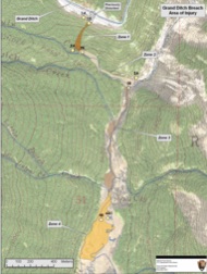
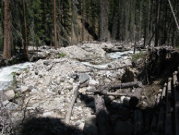
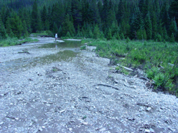
The Colorado River has its headwaters on the west side of Rocky Mountain National Park, in Colorado. However, the National Park was formed in 1915, long after the initiation of water development in the Colorado River basin, and within the park. The Grand River Ditch was developed starting in the 1880s to capture the flow of 13 streams that drain the eastern slopes of the Never Summer Mountains, and divert it over Poudre Pass and into the Poudre River drainage where it has been used for irrigated agriculture for more than 100 years, and is now also used to provide water for urban use. The impacts of the ditch on riparian ecosystems of the Kawuneechee Valley (the main Colorado River valley in RMNP) has been one of our long-term projects supported by RMNP. Graduate students Shaunda Wenger, Rodney Chimner, Scott Woods, and Cherie Westbrook have worked on this program. The results of their work is a series of theses, dissertations, reports and journal articles. In 2003 the Grand Ditch breached, as water flowed over the top of the ditch banks, and the contents of the ditch soaked hillslopes above Lulu Creek, and the hillslope dramatically collapsed eroded a deep trench. The water and sediment cascaded down through Lulu Creek, the upper Colorado River valley and into the Lulu City wetland causing tremendous damage to streams and vegetation. Reports have documented the damage from this event, and the US and the Water Supply & Storage company settled a law suit that provided $9 million for restoration of damage to Lulu Creek, the Colorado River and Lulu City wetland. This project has progressed through the damage assessment phase, and restoration options are currently being analyzed through and EIS process. Graduate student Covey Potter and I are working to quantify the impacts, and collect information on reference areas that can be used in restoration design for Lulu City wetland and the Colorado River floodplain. Center map below shows origin of breach, and four zones impacted, 1 is hillslope, 2 is Lulu Creek (photo at right), 3 is Colorado River, 4 is Lulu City wetland (left photo) with up to 1 m of sediment deposited.