CENTRAL ORGANIZING IDEA: The structure of terrestrial vegetation is driven by the timing and amount of water available to plants as modified by seasonal temperature regimes. The most fundamental mapping unit of the rangeland manager is the range site, which represents areas of similar site potential.
OBJECTIVES:
[2,4,6]Objective 1. Help students understand why plants with different life forms grow where they grow.
[2,4,6,7]Objective 2. Give students an overview of vegetation structure and productivity of world rangelands with emphasis on temperate grasslands and shrublands.
Teaching points:
1. The life form of vegetation (Cover Type, e.g., shrubs vs grass) found in an area
is a function of the amount of precipitation and the coincidence of precipitation
and potential evaporation [examples are temperate areas that receive the bulk of
precipitation in the winter (non-growing season) vs summer, growing season
precipitation]. The composition of vegetation expressed on an area may be
modified by, soil texture, associated plants (composition matrix), terrain (slope,
aspect), salts, soil depth, water run-on, etc.
2. Vegetation is dynamic and may exist in several different mixes, depending on
internal and external influences. [Although we will take up the issue later, we
need to point out that the same area might support a continuum of early seral to
late seral plants. We often see a large number of different kinds of plants that
might occupy a site following disturbance, i.e., early seral stages; but in late
seral stages there is a remarkable convergence of plants that occupy similar
sites.]
3. The ultimate integrator of environmental variables (habitat factors) is the
vegetation. The vegetation is an expression of site potential. Site potential is
characterized by species composition or productivity. In range management
these ecological response units are called range sites.
METHOD 1. [The book does not have a chapter that corresponds to this section]
Short lecture. Provide students with some general rules that relate climate to different biomes and other habitat factors and explain local variation.
1. Climate, represented by temperature and precipitation, determines
the structure (life forms) of the vegetation.
2. Locally, soil water and nutrients determines the mix of plants in the
stand. These are often a reflection of soil texture. Soil texture
regulates that amount of water storage and the total water
availability.
3. Rules:
a. areas with >600 to 800 mm precipitation will probably
be dominated by trees. Trees can grow in dryer areas,
but are often absent because of fire or prolonged
drought. In temperate zones, deciduous trees like
about an equal amount of water in the non-growing
and growing season. If a mix of deciduous and
coniferous tree are found in the same area, the conifers
occupy the more xeric sites. Of course, trees exist in
areas of stored water can also support trees. The range of
tolerance of some tree species and potential
evaporation also broadly define where trees will grow.
See Holdridge, page 5.
b. stored water is required to support shrubs. Therefore,
areas with mostly winter ppt often support shrubs,
while areas with growing season ppt often support a
herbaceous layer of grasses and forbs.
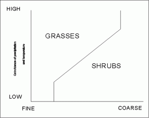
c. dominance by shrubs or grasses depends on the
coincidence of actual precipitation and potential
evapotranspiration, as that interacts with soil texture.
Generally the greater the difference, the greater the
chance shrubs will dominate. Shrubs and grasses may
be co-dominant under low coincidence and fine soils
or high coincidence and coarse soils.
4. Rangelands are represented by many structural types representing very-arid to
sub-humid climates.
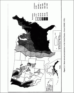
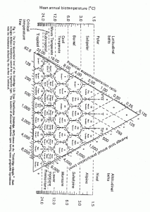
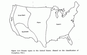
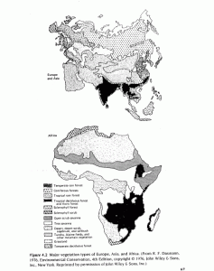
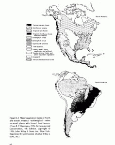
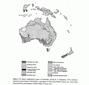
Short lecture. The figures on pages 3 to 10 are intended to illustrate (1) different patterns and amount of rainfall received in North America, (2) corresponding cover types and (3) world wide cover types.
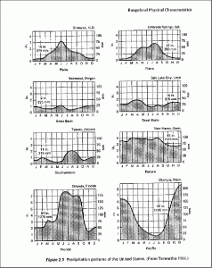
TASK: Answer these questions:
1. You are in the high desert of eastern Oregon; ppt is about 250 mm. What is the structure of
the vegetation?
2. You are in the sandhills of Nebraska; ppt is about 400 mm. What is the structure of the
vegetation?
3. You are in northeast Morocco; ppt is about 250 mm. What is the structure of the vegetation?
4. You are driving up from Houston, TX on Highway 59 or 69 through a mixed hardwood
forest. Suddenly, like someone drew a line on the map, you are in a coniferous forest.
What probably happened?
5. Think about the area you come from. What is the structure of the vegetation? Why do those
plants grow there? Are they native? Are they “good” plants?
What distinguishes grasses from forbs from shrubs from trees? What do these plants look like?? What are the major grasses, forbs, shrubs or trees one might expect to see? You can’t be expected to know them all; nor am I able to show you a specimen of all the plants. I am trying to expand the resources available to you. Which plants are found where and what do they look like?
I highly recommend you purchase from the Cooperative Extension Resource Center, 115 General Services Bldg, Bulletin 450-A, “Colorado Native Grasses.” (About $4.00) We use many plants as examples in this class.